Death Valley is a National Park that everyone should experience at least once in their lifetime. This is not only a unique place in the United States, but it’s also unique in the world. A day trip to Death Valley is not only a beautiful adventure, but it’s also educational.
While it seems extremely remote and isolated, it’s actually pretty easy to get to from Las Vegas, making a day trip plausible.
However, to fully relax and appreciate the experience, you may want to make this a two-day trip.
Death Valley is designated as an International Dark Sky Park, so you can see the night sky in all its glorious splendor here.
There are accommodations inside the park at Stovepipe Wells, Panamint Springs and at Furnace Creek. Whether you want to stay in a simple tent cabin or a luxury resort hotel, Death Valley has a wide range of options.
Be aware, the best times to go to Death Valley is between November and March when the weather is pleasant.
No matter what time of year you go, be sure to bring plenty of water, as well as some snacks. Make sure your car is in good shape, and while gas is expensive in the park, it’s still a good idea to keep your tank topped off.
Getting There
Before you head out on the road, be sure to gas up your vehicle; fuel prices inside the park are notoriously expensive, as much as $2 per gallon more than in Nevada. Likewise, leave early, it will be a long day.
There are a few ways to get to Death Valley from Las Vegas, and the fastest way is to go “over the hump to Pahrump”.
This is also the most scenic route, taking you through the stunning Red Rock Canyon National Conservation Area just west of Las Vegas, onto Highway 160.
This may also turn out to be a slow way, as you’ll undoubtedly stop to take a lot of pictures along the way! However, this road does have some steep grades, and Mountain Springs Summit, at 5,500’, may have snow during the winter. This road will take you into Pahrump; gas up the car here before going any further.
From Pahrump, you have two options; you can take the long, scenic route down Highway 178 through Shoshone California up to Ashford Junction, Badwater and then to Furnace Creek.
If you choose this route, it may be wise to arrange for a night in the park. Alternately, you can take Highway 160 north out of Pahrump to Amargosa Valley, and then onto Highway 190.
If you’d like to avoid the mountains, you can also go on Highway 95 north out of Las Vegas, past Nellis AFB straight to Amargosa Valley.
Gas up here, at the Area 51 Alien Travel Center and Brothel; yes, it’s not only an alien-themed gas station and convenience store, but there’s also a legal brothel out back. It’s one more place to take a few memorable pictures! From here turn onto Highway 190, also known as Death Valley Road. This will take you straight into the park.
Places to See Inside Death Valley
Once you reach the park, play it safe and stay on the well-marked, main roads; GPS is not always accurate here, and many tourists have gotten lost, wandering down on unmarked dirt roads. Likewise, you may not have any cell service here.
Zabriskie Point
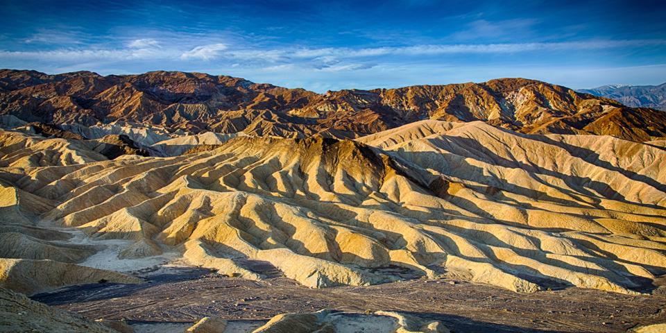
We’ll assume you took the faster route, from Amargosa Valley to Highway 190; the first stop on the journey will be Zabriskie Point.
This was once a borax mining area.
Stop at the lookout point for an arresting view across the undulating, colorful badlands.
The walk to the viewing area is accessible to most people, however, it does have a fairly steep incline.
Here, you can read signs about the history of the badlands, as well as the minerals that create vivid colors here.
Furnace Creek
If you keep going on Highway 190, the next stop is the Furnace Creek visitor center.
This is where you will also pay the entrance fee to the park.
You can also pick up free maps here, and ask the rangers any questions you may have. Furnace Creek is also the largest community within the park, and has a gas station, a general store, and a few restaurants. If you want to spend the night in the park, there are campgrounds here, as well as an inn and two resorts.
The Borax Museum has interesting relics from the borax mining days, and further down the road, is the entrance to the old Harmony Borax processing plant, with a 20 mule team wagon out front. The Death Valley History Association is also in Furnace Creek, and they offer guided tours during the winter months.
The Salt Creek Interpretive Trail
Keep driving on Highway 190, and soon you’ll see a sign for Salt Creek. The Salt Creek Interpretive Trail is a boardwalk that’s easily accessible.
The trail surprisingly winds its way through a small wetlands area. Much of the creek dries up in the summer, but the end of the trail always has water.
There are interpretive signs all along the way, highlighting the unique wetlands biology here in the middle of the desert. Once you reach the headwaters, keep an eye out for the rare Salt Creek Pupfish; this tiny fish lives nowhere else on the planet.
Mesquite Sand Dunes
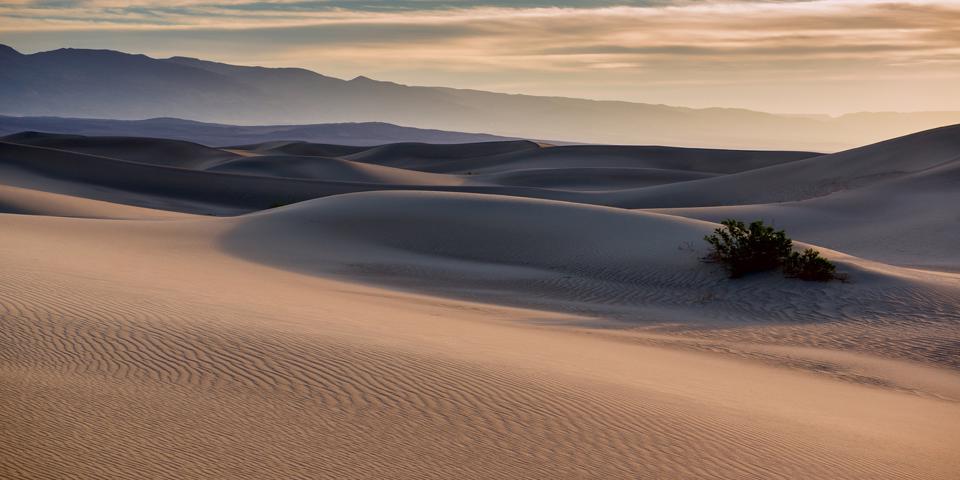
The Mesquite Sand Dunes are not the only dunes here, but they’re the most accessible. This is one of the places director George Lucas filmed the original Star Wars. You may recognize it as the dusty home of Luke Skywalker, the planet of Tatooine.
Stovepipe Wells
There is a gas station, a convenience store, a saloon, and a ranger station here. It’s a good place to stop to top off the tank and get a few refreshments.
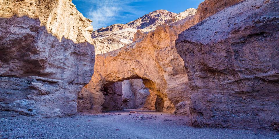
Mosaic Canyon
If you like slot canyons, this one is an easy hike. The smooth, polished rock walls are caused by flash floods raging through the canyons, so it’s important that you never enter a slot canyon if it’s raining.
Artist’s Palette
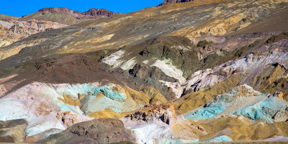
The world-famous Artist’s Palette is a 9-mile drive, and sections of the road are quite twisty and narrow. This is a popular drive, so also be prepared for some traffic.
The first viewing area has a fairly large parking lot, but the climb to the viewing areas can be a challenge for some. But if you make it, the view of the painted, undulating hills is stunning.
The second viewing area has a smaller parking lot, with a shorter climb, but the colors here are much more vivid and dramatic. This is definitely time to get the camera out.
Devil’s Golf Course
Make a turn onto Salt Pool Road for an otherworldly landscape of mounds of earth encrusted with fragile sand. If you walk over the surface it makes strange popping sounds, but be careful, occasionally the ground opens to reveal salt pools underneath.
Natural Bridge
The Natural Bridge Canyon Trail will take you on a 1-mile hike to the park’s most popular natural bridge. Half a mile from the entrance the canyon walls narrow into a 50-foot tall natural bridge spanning the narrow red sandstone canyon.
Badwater Basin
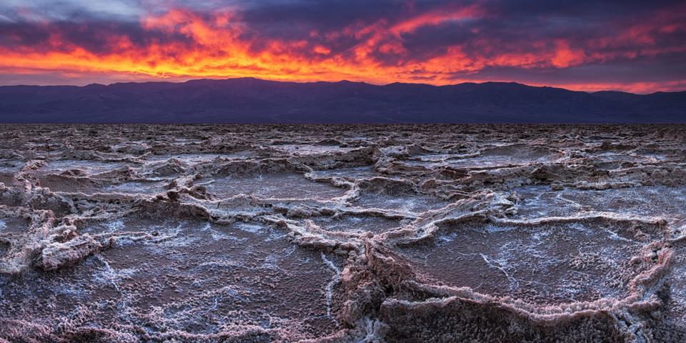
This is perhaps the park’s best-known location; it’s the lowest point in all of North America, as well as the driest and hottest place on earth. If there is one place to visit in Death Valley, this is it.
The first thing you’ll want to do is take a picture of the sign.
One of the first things you’ll notice is the small pool of highly concentrated salt water that never dries out. This is the very lowest point. Beyond that, the salt flats stretch out as far as the eye can see, to the snow-capped mountains beyond. Walking out onto the gleaming, white salt flats is a surreal, otherworldly experience, to say the least.
The last stop is Ashford Mill. These are the ruins of what was once a thriving gold mining town, originally built in 1914 by the Ashford brothers. Gold ore from the Golden Treasure Mine, which was 5-miles to the east, up in the mountains, was processed here. All that remains today are a few crumbling ruins.
Getting Back to Las Vegas
From here, you can continue driving to Shoshone, California, and on to Pahrump. Shoshone is a cute little town, with an interesting gift shop and an overpriced gas station. If you’d like to stop for the night, the Tecopa Hot Springs are just 9-miles to the east of Shoshone. The Tecopa Hot Springs Resort is a great place to soak your weary muscles after a busy day hiking. There’s also a restaurant there, as well as the mineral water hot springs, naturally heated by the earth.
Likewise, you can continue 30 miles east to Pahrump for a hot meal and a place to rest your weary bones.
In any case, you’ll want to gas up the car in Pahrump before you head back to Las Vegas; gas in Shoshone is often nearly $2 more per gallon than over the border in Pahrump. From Pahrump, the trip back to Vegas is straightforward, anyway you choose to go.