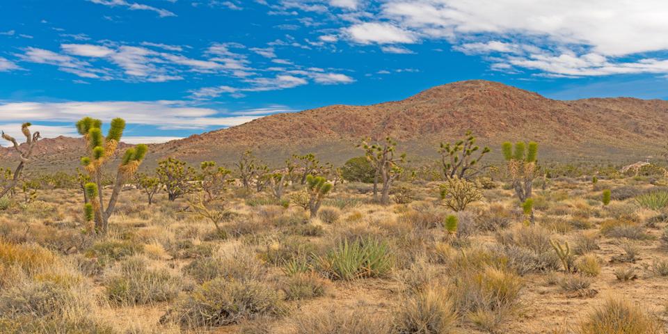
To the west of Las Vegas is the pristine desert environment of the 1.6 million-acre Mojave National Preserve. Here you will find high mountain peaks covered with snow in the winter and large forests of exotic Joshua Trees. The Chemehuevi people lived here, hunting deer and bighorn sheep, gathering sweet prickly pear and mesquite seeds, and roasting agave blossoms.
As you climb in elevation, you’ll drive through forests of stately Joshua Trees. These are not really “trees” but a type of yucca. These venerable desert denizens can grow up to 50 feet in height, living for 1,000 years. The Native Americans used the stiff leaves to weave baskets and sandals, in addition to harvesting the flowers and seeds for food. They also used the roots to make a red dye. The Mojave National Preserve has some of the most impressive stands of Joshua Trees in the world.
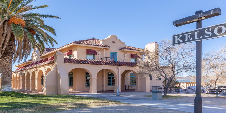
The Kelso Depot Visitor Center
This is a rugged and uniquely scenic terrain, easily reached from Las Vegas from I-15. Be sure to fill up your gas tank before you venture into the preserve. Also, this is a desert, and if you venture here during the summer, bring plenty of water and make sure your vehicle can handle the heat.
The first place to see is the visitor center at the Kelso Depot, 90942 Kelso Cima Rd, Kelso, CA. Simply drive across the California border, take Exit 286 for Nipton Road, then take Morning Star Mine Road to Kelso Cima Road.
The Kelso Depot stands out as a quiet oddity in the middle of the desert. The first railroad depot in Kelso opened in 1905. It was a modest, simple wooden building, and a small railroad and mining town grew up around it. By 1924, the elegant Spanish Mission Revival depot building was complete. The building included a restaurant, and the population of Kelso continued to grow to 2,000 people by the 1950s. However, when the Vulcan mine closed in 1962, the town began its slow decline. By 1985, Kelso was officially a ghost town.
Today, the beautifully restored depot building is maintained by the Bureau of Land Management, and serves as the preserve’s visitor center. It sits right in the middle of the park, and it’s your resource for information. The rangers are very knowledgeable about places to go to the Mojave Preserve, and you can watch the 15-minute video about the Mojave Preserve, as well as visit the museum and gift shop.
The Kelso Dunes
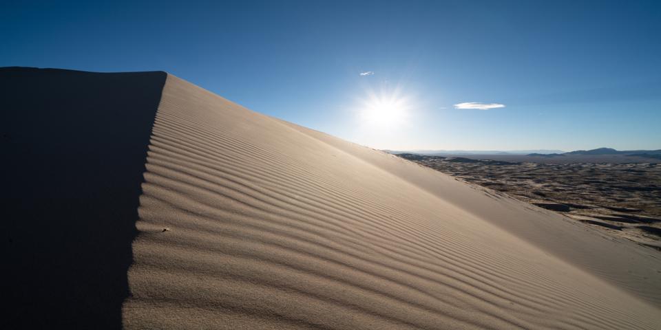
The dunes are just southwest of the visitor center. The Kelso sand dunes rise 650 feet above the plain and cover 45 square miles. The Kelso Dunes are “booming dunes” known for the phenomenon of singing sand. If you’d like to experience this “singing,” climb to the top of the dunes. Be aware that this could be a challenging hike. Then slide down slowly; this may generate a low-frequency rumble that you can both hear and feel. The booming phenomenon is easier to produce when the sand is extremely dry.
Cima California
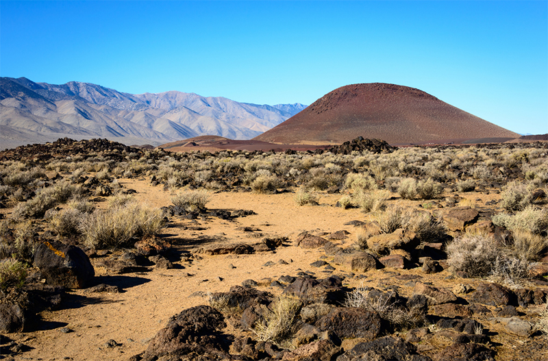
Like Kelso, Cima is now considered a ghost town. However, the railroad still runs through it, and the rustic old buildings make a great photo opportunity. Likewise, Cima also sits in the middle of one of the densest Joshua Tree forests in California. Just to the northwest of the ghost town is the Cima Dome and Volcanic Field National Natural Landmark. Cima Dome rises to 5,745 feet above sea level, and it’s a prominent feature in this exotic desert landscape.
Cima Dome and Volcanic Field
The remarkably smooth dome-shaped Cima Dome itself rises to a height of 1,500 feet above the volcanic plain, and the volcanic field includes 40 volcanic cinder cone vents. But don’t worry, these ancient volcanoes are extinct and completely safe. The dome spans seventy square miles, and it’s the most symmetrical dome in the country.
The hike up to the dome is 4 miles each way along the Teutonia Peak Trail. To get to the trailhead from Cima, drive north on Cima Road for 6 miles to a turnout for the trailhead. Before you head out, bring a map, get some GPS coordinates, and know where you’re going, and how to get back. But don’t as the park rangers point out, you shouldn’t rely on only GPS because such navigation is often unreliable in remote locations.
While it’s a fascinating hike through the Joshua Forest, it’s best done when the weather is cool. The hike will lead you through the Joshua Forest, with not only the Joshua Trees but lots of other types of desert flora too. You’ll also pass through an old mining area; be careful, those old mine shafts are deep, and there won’t be anyone nearby to help you if you fall in.
Finally, you’ll reach the short, steep ascent up to Cima Dome, with its jumble of huge, granite boulders. From up here, you’ll be treated to an expansive view of the desert valley below.
The Mojave Phone Booth
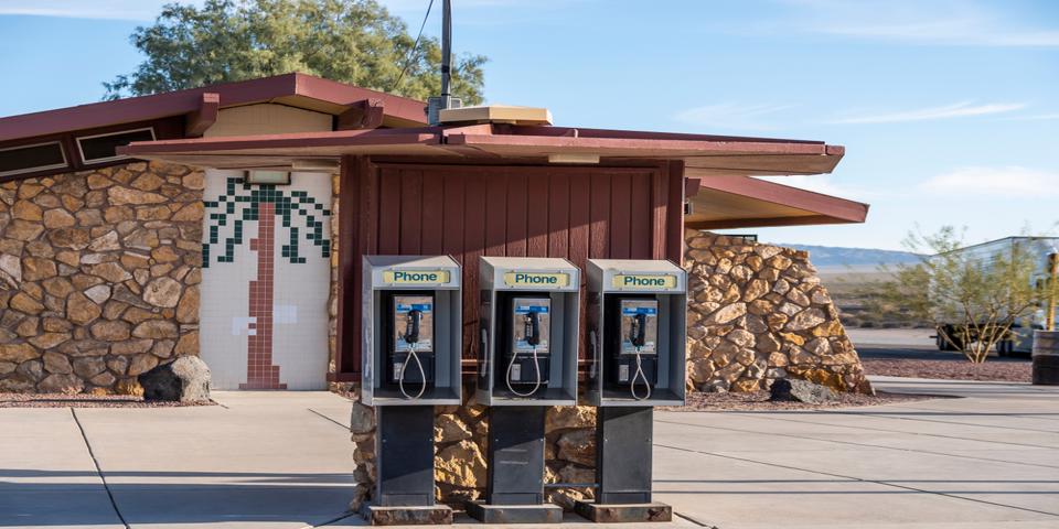
Nothing remains of the mysterious Mojave Phone Booth, which once stood at the crossroads of two dirt roads. GPS coordinates 35.285827, -115.68463
The phone booth was originally set up in 1948 for the benefit of the local miners. However, it gained notoriety in 1997, when a man from Los Angeles discovered it while exploring the surrounding desert. He wrote about his odd discovery in an obscure underground magazine and published the telephone booth’s number. Soon, a website was devoted to the Mojave phone booth, and the New York Times picked up the story. People began calling the phone booth, while others made the trek to the booth to answer the calls, often camping nearby.
Eventually, the park service shut the party down in 2000 by having the phone booth removed. Since then, several movies and books have been written about the mysterious phone booth in the middle of nowhere. While the phone number was retired for many years, in 2013 it was resurrected as a conference call number at 760-733-9969.
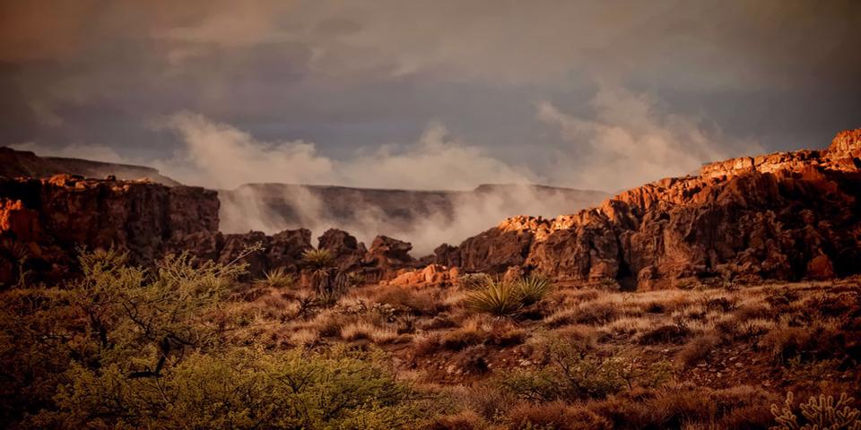
Hole in the Wall
This is a developed campground here, with 35 campsites, some large enough for RVs. There is water and toilets, but no other amenities. However, you might think twice about driving a motorhome in; there are around 9-miles of dirt road, complete with sand, washboard, and potholes.
Hole in the Wall is off Black Canyon Road, and it’s famous for its the Swiss cheese-like holes in the towering rock formations. The formations were formed over millions of years, as volcanic eruptions and gases created the unusual holes in the massive rocks.
At Hole in the Wall, you can hike the unusual Rings Loop Trail. The trail is mostly easy, but the last bit is moderate to extreme; you have to pull yourself up the last leg by metal rings attached to the rock walls. This section is in a very narrow slot within the rocks. Big people won’t be able to fit, and unless you have good upper body strength, you won’t make it. While it’s a fun hike, be careful; you’re out in the middle of nowhere, and cell service can be weak to nonexistent.
Mitchell Caverns
Many prehistoric and archaeological discoveries have been made in and around the Mitchell Caverns, including that of an extinct Shasta ground sloth from the Pleistocene. The caverns were also a sacred place for the Chemehuevi, who called the caverns “the eyes of the mountain.”
The cavern visitor center is at 38200 Essex Rd, Essex, CA. Tours are on the weekends, and they often sell out quickly because only 15 people are allowed on each tour. It’s only $10 per car and $10 per person for the tour, but make reservations ahead of time.
The caves are incredible, and the view from outside the caves is stunning. You’ll be high above the desert floor, with an expansive view of the valley below. Your guided tour begins through the “eyes” of the mountain, and once inside, the paved trail is lined with lights highlighting the intricate cave formations. There are stalactites, stalagmites, and you may even see a bat.
Clark Mountain
At 7,929 feet, Clark Mountain is the highest in the Mojave National Preserve, often covered with snow in the winter. At the top is a sky island, covered in a white fir forest. It’s a wilderness area, and unless you’re a mountain climber with a 4×4 vehicle, the mountain is best admired from afar.
Baker, California
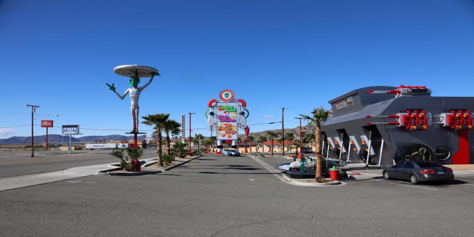
Once you’re done exploring the desert, you’ll want to stop in at Baker, California, to get gas for the trip back. While you’re there, you can also grab some gyros at the Mad Greek Cafe and marvel at the “world’s tallest thermometer.”
Alien Fresh Jerky is also an amusing stop in Baker; it’s a weird, spaceship-inspired building complete with gray alien statues and a car that looks like Doc Brown’s DeLorean from Back to the Future. They have every type of jerky you can imagine. You can’t miss the place; it’s on the way to the on-ramp for I-15 back to Las Vegas. Otherwise, there is not much else of interest in Baker.
The Mojave desert is a unique place, and we’re very lucky to have it so close to both Las Vegas and Los Angeles.